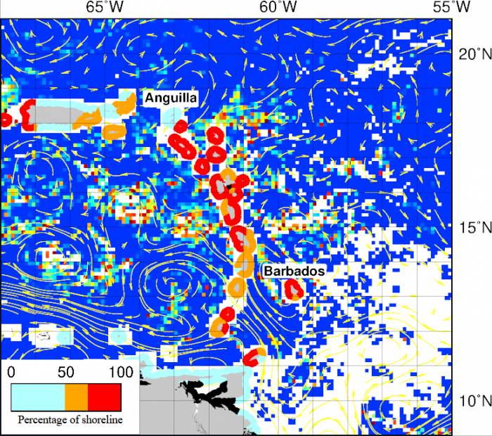
Since 2011, large accumulations of Sargassum is a recurrent problem in the Caribbean Sea, in the Gulf of Mexico and tropical Atlantic. These events can cause significant economic, environmental and public health harm. These experimental Sargassum Inundation Reports (SIR) provide an overview of the risk of sargassum coastal inundation in the Caribbean and Gulf of Mexico regions. Using as core inputs the AFAI (Alternative Floating Algae Index) fields generated by the University of South Florida (USF), the algorithm analyses the AFAI values in the neighborhood (50 km) of each coastal pixel and, computing the difference between those values and a multiday baseline, classifies the risk into three categories: low (blue), medium (orange) and high (red). In black are areas with not enough data. The two ad-hoc thresholds used for classification are 0.001 and 0.003. The vectors in the images represent the geostrophic currents. SIR is the result of the collaboration between the Atlantic Oceanographic and Meteorological Laboratory (NOAA/AOML), NOAA/CoastWatch/OceanWatch, and USF
Sargassum Inundation Report Contact Information:
Joaquin Trinanes
NOAA/Atlantic Oceanographic & Meteorological Laboratory
4301 Rickenbacker Causeway
Miami, FL 33149, USA
Joaquin.Trinanes@noaa.gov
Gustavo Goni
NOAA/Atlantic Oceanographic & Meteorological Laboratory
4301 Rickenbacker Causeway
Miami, FL 33149, USA
Gustavo.Goni@noaa.gov
Chuanmin Hu
USF, College of Marine Science
140 7th Avenue S, MSL119
St. Petersburg, FL 33701, USA
huc@usf.edu
References: USF Sargassum Watch System, Atlantic OceanWatch
Disclaimer: This is an experimental product and still subject to validation by NOAA/AOML, NOAA/CoastWatch/OceanWatch, and USF.